Difference between revisions of "Val Verde County"
From Texas Century Club
Dell.Little (Talk | contribs) (→Region 5 Edwards Plateau) |
Dell.Little (Talk | contribs) |
||
| (17 intermediate revisions by one user not shown) | |||
| Line 1: | Line 1: | ||
==[[:Category:Region 5|Region 5 Edwards Plateau]]== | ==[[:Category:Region 5|Region 5 Edwards Plateau]]== | ||
| − | '''Previous county:''' ''[[Uvalde County|Uvalde]]'', '''Next:''' ''[[Van Zandt County|Van Zandt]]'' | + | '''Previous county:''' ''[[Uvalde County|Uvalde]]'', '''Next:''' ''[[Van Zandt County|Van Zandt]]'', '''All Counties:''' ''[[:Category:All Counties|Alphabetically]]<br />'''Bordering counties''' - '''North''' ''[[Crockett County|Crockett]]'', '''Northeast''' ''[[Sutton County|Sutton]]'', '''East:''' ''[[Edwards County|Edwards]]'', '''Southeast:''' ''[[Kinney County|Kinney]]'', '''West:''' ''[[Terrell County|Terrell]]''<br /> |
---- | ---- | ||
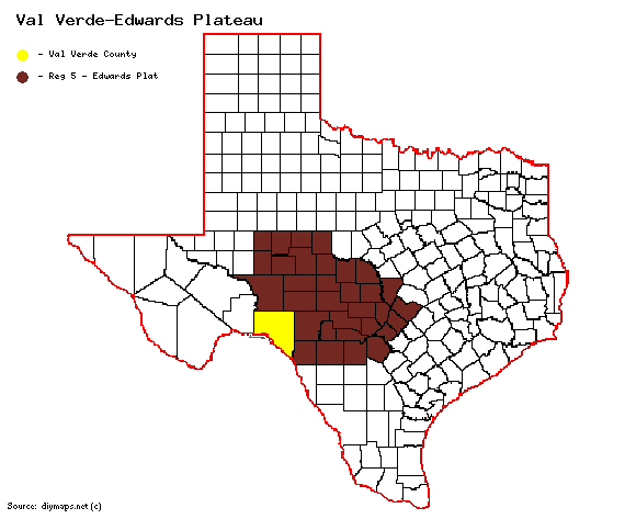
| − | + | [[File:Val Verde-Edwards Plateau.gif|570px|right]] | |
| + | |||
| + | == '''Century Clubbers''' == | ||
| + | {{#iDisplay:https://docs.google.com/spreadsheets/d/1zhY9yjEhg__aTzBySCcaEZHHR7hcLunUZoo1wh6pd08/pubhtml?gid=0&single=true|250px}} | ||
| + | |||
| + | == '''[http://ebird.org/ebird/top100?locInfo.regionType=subnational2&locInfo.regionCode=US-TX-465&year=AAAA eBird Top 100]''' == | ||
| + | |||
| + | == '''County Big Years & Big Days'''== | ||
| + | <span style="font-size:120%">'''[[County_Big_Years|All County Top 10 Big <span style="font-size:130%">Years]]''' | ||
| + | |||
| + | {{#iDisplay:https://docs.google.com/spreadsheets/d/1y0f8LAqcOGw4pEOl4uEnQq-qLqurSnI2B-Bp5wohKJ8/pubhtml?gid=0&single=true|100%|400}} | ||
| + | |||
| + | <span style="font-size:120%">'''[[County_Big_Days|All County Top 10 Big <span style="font-size:130%">Days]]''' | ||
| + | |||
| + | {{#iDisplay:https://docs.google.com/spreadsheets/d/1uZWDBVBrmSRCfXd5jxhF77sFMyq3SQettJ35o373y2k/pubhtml?gid=0&single=true|100%|325}} | ||
---- | ---- | ||
| − | + | == '''[https://ebird.org/region/US-TX-465/hotspots?yr=all&m= eBird Hot Spots - Val Verde County]''' == | |
| + | |||
| + | == Guides and Resources == | ||
| + | *<span style="font-size:120%">'''[https://birdinghotspots.org/region/US-TX-465 Birdinghotspots.org - Val Verde County]''' | ||
| + | *'''[https://tpwd.texas.gov/huntwild/wildlife/wildlife-trails/hotw Great Texas Wildlife Trails - Heart of Texas West Region]''' at Texas Parks & Wildlife | ||
| + | :*'''[https://tpwd.texas.gov/huntwild/wildlife/wildlife-trails/hotw/north-rio-bravo-loop Rio Bravo Loop]''' Includes: | ||
| + | ::* San Felipe Creek | ||
| + | ::* Paseo de Los Ninos Nature Trail | ||
| + | ::* Laguna de Plata, Del Rio Duck Ponds | ||
| + | ::* Lake Amistad NRA | ||
| + | ::* Seminole Canyon SP & HS | ||
| + | ::* White Shaman Preserve | ||
| + | ::* TxDOT Roy Bean Information Center | ||
| + | ::* Devil's River SNA | ||
| + | :*'''[https://tpwd.texas.gov/huntwild/wildlife/wildlife-trails/hotw/sonora-loop Sonora Loop]''' Includes: Jarett Juno Ranch | ||
| + | |||
| + | *Dell's map of [https://drive.google.com/open?id=1WYqBhkRTHuiBYQWlcGyrWB1cssu0gXQi&usp=sharing| Val Verde County] for birding and exploring. It includes eBird Hotspots and additional potential locations, creek crossings and roads that may be productive. | ||
| − | |||
| − | |||
---- | ---- | ||
| − | '''Previous county:''' ''[[Uvalde County|Uvalde]]'', '''Next:''' ''[[Van Zandt County|Van Zandt]]'' | + | '''Previous county:''' ''[[Uvalde County|Uvalde]]'', '''Next:''' ''[[Van Zandt County|Van Zandt]]''<br />'''Bordering counties''' - '''North''' ''[[Crockett County|Crockett]]'', '''Northeast''' ''[[Sutton County|Sutton]]'', '''East:''' ''[[Edwards County|Edwards]]'', '''Southeast:''' ''[[Kinney County|Kinney]]'', '''West:''' ''[[Terrell County|Terrell]]'' |
[[category:Region 5]] | [[category:Region 5]] | ||
[[category:All Counties]] | [[category:All Counties]] | ||
Latest revision as of 21:22, 10 April 2025
Contents |
Region 5 Edwards Plateau
Previous county: Uvalde, Next: Van Zandt, All Counties: Alphabetically
Bordering counties - North Crockett, Northeast Sutton, East: Edwards, Southeast: Kinney, West: Terrell
Century Clubbers
eBird Top 100
County Big Years & Big Days
eBird Hot Spots - Val Verde County
Guides and Resources
- Birdinghotspots.org - Val Verde County
- Great Texas Wildlife Trails - Heart of Texas West Region at Texas Parks & Wildlife
- Rio Bravo Loop Includes:
- San Felipe Creek
- Paseo de Los Ninos Nature Trail
- Laguna de Plata, Del Rio Duck Ponds
- Lake Amistad NRA
- Seminole Canyon SP & HS
- White Shaman Preserve
- TxDOT Roy Bean Information Center
- Devil's River SNA
- Sonora Loop Includes: Jarett Juno Ranch
- Dell's map of Val Verde County for birding and exploring. It includes eBird Hotspots and additional potential locations, creek crossings and roads that may be productive.
Previous county: Uvalde, Next: Van Zandt
Bordering counties - North Crockett, Northeast Sutton, East: Edwards, Southeast: Kinney, West: Terrell
